 2:40 AM
 specialshowtoday

 There's nothing like a helicopter
flight over Angkor to provide insight into how vast the ancient city
really is. A new report released by the U.S.-based National Academy of
Sciences has revealed a much grander Angkor landscape than previously
known, one without parallel in the pre-industrial world.
There's nothing like a helicopter
flight over Angkor to provide insight into how vast the ancient city
really is. A new report released by the U.S.-based National Academy of
Sciences has revealed a much grander Angkor landscape than previously
known, one without parallel in the pre-industrial world.
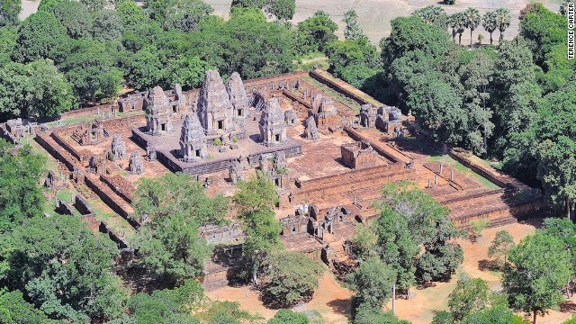
East Mebon Temple
STORY HIGHLIGHTS
- A helicopter camera has changed the way travelers will experience Angkor Wat and other Khmer temple-cities
- Consortium of archaeologists brought in to fill in the blank spaces on map of Angkor
- Locals hope discovery will inspire travelers to explore Siem Reap's lesser known Khmer ruins
Siem Reap, Cambodia (CNN) -- Visit Cambodia's number
one tourist attraction, Angkor Wat, with the average tour guide and
you'll probably leave the UNESCO World Heritage Site with your head
swimming in dates, dimensions and unpronounceable names of kings.
Jaya-who?
You might also get the
impression, as I did when I first visited two years ago, that the
magnificent temple complex you scrambled around in sweltering heat is
confined within its sturdy walls and scenic moat, and the city ended
there.
Turns out that's not the case.
A new report released by the U.S.-based National Academy of Sciences
(NAS) highlighting the results of an April 2012 airborne laser survey
-- the first of its kind in Asia, covering 370 square kilometers of
northwest Cambodia's Khmer Empire archaeological sites -- has revealed a
much grander Angkor landscape, one without parallel in the
pre-industrial world.
Even more sensational,
the June announcement of the findings confirmed the existence of a huge
medieval city buried beneath impenetrable jungle on a remote mountain.
Re-writing Cambodia's history books
Angkor was the capital of
the Khmer Empire, which was founded in 802 AD on Mount Kulen when
Jayavarman II was declared universal monarch.
These days the most
popular Angkor sites for tourists are Angkor Thom, which is home to
Bayon and its massive carved smiling faces; magnificent Angkor Wat; and
smaller temples such as Ta Prohm, Preah Khan, Pre Rup and Ta Nei.
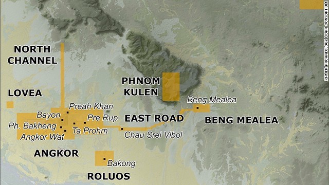 Yellow indicates aerial surveys areas.
But the precise data
gathered by LiDAR, a remote sensing laser instrument, reveals that
Angkor was actually a monumental, formally planned and low-density
mega-city.
Phnom Kulen, or Mount
Kulen, meanwhile, 48 kilometers north of Siem Reap, has been identified
as the location of the medieval city of Mahendraparvata, or the Mountain
of Indra -- King of the Gods.
This makes Angkor the
world's largest urban conurbation prior to Britain's 18th-century
Industrial Revolution -- a revelation that completely alters how experts
are looking at the area.
While the ancient urban
network's existence was mentioned in inscriptions and long suspected by
French archaeologists working in Cambodia, it couldn't be confirmed due
to the remoteness of ruins already discovered on the plateau, the
inaccessibility of much of the mountain and the existence of landmines
installed by the Khmer Rouge.
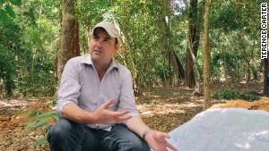
Dr. Damian Evans of the LiDAR mission uses a map to explain the monumental scale of the mega-city of Angkor.
One of the authors of the NAS report, Australian archaeologist Dr. Damian Evans, is director of the University of Sydney's Robert Christie Research Centre in Siem Reap and the chief architect behind the costly LiDAR mission.
He brought together
eight different archaeological organizations, including the Cambodian
government's APSARA Authority, which manages the region's archaeological
sites, to form the Khmer Archeology LiDAR Consortium, which raised funds for the project and shared data.
The LiDAR mission was
conceived to fill in the blank spaces on the map of Angkor, Evans says,
as we slip into the jungle just outside the walls of Angkor Wat.
"Nothing on the forest floor is random, not even a termite mound," Evans explains as he points out anthills.
"While a lot of the city
is buried beneath the ground, it impacts the surface in subtle ways.
The movements, activities and actions of these people hundreds of years
ago remain inscribed into the landscape.
"None of these lumps and
bumps and dips made any kind of sense, but once you see the LiDAR
imagery, it's strikingly evident that what you're looking at are the
remains of a city associated with Angkor Wat."
Using technology to speed things up
Out of the sight of the
one million tourists who visit the temple-city every year,
archaeologists are at work on excavation projects.
They use found remnants
of the region's rich Khmer history, culture and way of life to piece
together a story that's continually developing, changing visitors'
understanding and experience of Angkor in the process.
Archaeologists have
worked on the ground here since naturalist Henri Mouhot stumbled upon
Angkor Wat in 1860, excavating temple ruins deep within jungles for
visitors to tour, peeling away vines from palaces for us to explore and
unearthing riches to be displayed in museums.
For many archaeologists,
a discovery can represent a lifetime's work. The LiDAR technology
changes all that, speeding up the process.
"What LiDAR takes away
is a little of the Indiana Jones stuff of whacking through cactus,
spiders, thorny trees and mud puddles," says American archaeologist Dr.
Miriam Stark, onsite in Siem Reap.
"You can still have your
spiders, snakes and bugs, and all those rich experiences, but now you
know you're getting somewhere, which is a lot more satisfying."
A taste of that Indiana Jones stuff awaits our party at 492-meter-high Mount Kulen, a 90-minute drive from Siem Reap.
Near Preah Ang Thom,
home to a colossal 16th-century reclining Buddha carved out of solid
rock, my photographer husband and I swap our four-wheel-drive vehicle
for motorbikes, riding behind local guides for a daylong bone-rattling
exploration of the eight-kilometer-wide and 32-kilometer-long mountain
plateau.
We cling on tight as our
guides, familiar with every cave and cranny on the landmine-riddled
mountain, tackle muddy trails up hills, bump over log bridges, fly
through fast-flowing streams, get stuck in sludgy puddles and go
off-road, bouncing along jungle tracks only they can see, every now and
again alighting to slash away vines and branches with a scythe to create
our own paths.
We hike to see enormous
carved stone statues of an elephant and lions at Sras Damrei (Elephant
Pond) buried deep within the forest and scramble about the ruins of
Prasat Rong Chen, the three-tiered laterite temple where the Brahman
priest made Jayavarman II a god-king.
We emerge from thick jungle to gaze at the red brick temple of O Paong, grass and trees sprouting from its cracks.
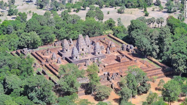 Angkor's splendid temple architecture.
Another day we visit
beautiful Beng Mealea, taken captive by tangled roots and a forest that
grows within and around the moss-covered temple, and the remote,
sprawling Koh Ker, where temple after crumbling temple wait to be
explored.
We see a total of four tourists the whole day.
"Digging" for ruins in the air
We also board the
helicopter that was equipped with the LiDAR instrument to view the
area's splendid temple-cities and grasp the size of the colossal new
cityscape that's been recently uncovered.
From the air it's easier
to understand how challenging the archaeologists' job must have been
before the device bombarded the ground with laser beams -- a million
pulses every four seconds -- to record data that ultimately provided the
precise information that has forever changed how archaeologists work.
At a traditional Khmer
stilted house on Siem Reap's riverside that serves as the Robert
Christie Research Centre, I meet archeology professor Dr. Roland
Fletcher, co-director of the Greater Angkor Project.
"I like to explain it like this," begins Dr Fletcher.
"When you came here you
landed at the airport and thought of yourself as driving to Siem Reap,
then driving from Siem Reap to Angkor. But when you were at the airport
you were really 15 kilometers inside the Angkor city and Siem Reap is in
the suburbs of Angkor ... at Angkor Wat you'd be right in the middle of
the city and everywhere you turned you would be looking across rice
fields and see rows and rows of timber houses with smoke rising from
them in the morning and the towers of shrines sticking up through the
trees ... it must have been an unbelievably beautiful place."
It's still a beautiful
place -- as the one million tourists who visited Siem Reap and its
Angkor temple-cities in 2012 would no doubt attest.
And hotel and tour operators are predicting a significant increase in tourist arrivals for 2013.
It could be some time
before more of the "lost city" of Mahendraparvata's sites are excavated
and its temples are made more accessible -- there's still much de-mining
to do on the plateau, too.
In the meantime,
however, locals are hoping the new discoveries inspire more travelers to
explore remote sites such as Koh Ker and Beng Mealea, and that the
intrepid will hop on the backs of motorbikes at Mount Kulen.
Getting there
Several airlines fly
directly to Siem Reap in Cambodia and 30-day tourist visas are available
upon arrival for many nationalities for $20. Bring passport photos.
Most visitors employ a local guide or hire a tuk-tuk or bikes to explore the Angkor Archaeological Park (open daily, 5 a.m.-6 p.m.).
An Angkor Pass can be purchased at the entrance gate: one-day $20, three-day $40 and seven-day $60.
ABOUTAsia Travel offers tours of the Angkor cities.
Backyard Travel offers one-day expeditions to Mount Kulen and day trips Koh Ker and Beng Mealea.
HeliStar offers flights over the Angkor cities, including to Mount Kulen and Koh Ker, beginning from $90.
 Posted in: World news


0 comments:
Post a Comment